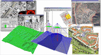
Geomaticyber gladly wanna expose to you the Photogrammetry application by using Leica Photogrammetry Suite software (
LPS)..This software usually used for the digital photogrammetry in designing the terrain for the any future development such as building,highway,housing and lot more..LPS is the alternative software used for process
aerial photograph taken by aircraft of the ground from elevated position.
Click on Image for Enlarge
Click on Image for Enlarge
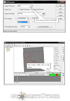
Screen Shoot from Geomaticyber Manual
People can download the manual following link below:
Geomaticyber LPS Manual
LPS Video Training Note: This software allowed us to create Digital Terrain Model (
DTM) for ground surface and we can save the job in the suitable format and then user can using ArcGIS software to make the further analysis..For your information the LPS software quite similar to ERDAS software..By posting this manual, i hope you can learn how to using the other land surveying software and increase your knowledge..
(^_^)v Resource & Reference : UiTM Survey Camp Manual &
Leica Geosystem